Types of Borders in Nigeria:
Nigeria's outside borders as a whole:
Nigeria's main boundary that separates it from neighboring countries is a superimposed boundary, imposed by the British during colonization. These boundaries are abundant in Africa, and have caused many conflicts by grouping tribes that tend to fight together. Nigeria itself is a compact state, because it is quite small and is not spread out very far. Also, Nigeria has a somewhat circular shape.
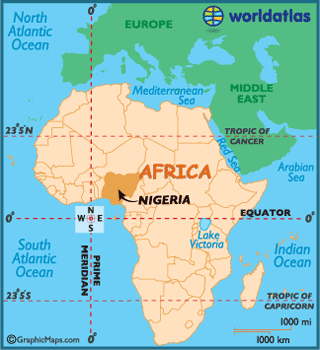
Here is a birds eye view of Nigeria, and the surrounding states.
Here is a birds eye view of Nigeria, and the surrounding states.
Borders Within Nigeria
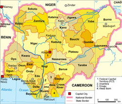
The individual states within Nigeria are separated by cultural boundaries, imposed by the government due to different conflicting tribes.
Here is a list of all of the states within Nigeria:
Abia State, Kwara State, Lagos State, Nasarawa State, Niger State, Ogun State, Ondo State, Osun State, Oyo State, Plateau State, Rivers State, Sokoto State, Taraba State, Yobe State, Zamfara State, Adamawa State, Akwa Ibom State, Anambra State, Bauchi State, Bayelsa State, Benue State, Borno State, Cross River State, Delta State Ebonyi State Edo State, Ekiti State,Enugu State, Federal Capital Territory, Gombe State, Imo State, Jigawa State Kaduna State, Kano State, Katsina State, Kebbi State, Kogi State
One of the main reasons all of the different ethnic groups have their own set areas is due to the states within Nigeria being specifically set up for different ethnicities, because it was believed that if each ethnic group had their own political control, there would be no attempts to break away and form independent countries. However, this control actually lead to minority ethnicities such as the Igbo ethnic group being discriminated against, and fueled their attempts to form their own state independent from Nigeria.
Boundary Changes over time:
There were 12 states within Nigeria in 1967
There were 19 states within Nigeria in 1976
There were 36 states within Nigeria in 1991
